Sheet A-23-CEUS-SSC Project GIS Data Summary
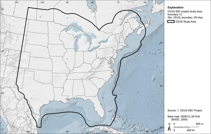
CEUS-SSC Study Area Boundary
Download: ![]() Download GIS Data |
Download GIS Data | ![]() Download PDF Figures for Technical Use
Download PDF Figures for Technical Use
Data Files: CEUS_boundary_R0.shp
Data Description: The CEUS study area boundary was developed to include the area of the CEUS and adjacent portions of Canada and Mexico. The western limit was set to 105 degrees west longitude, roughly corresponding to the Rocky Mountains eastern extent, and extending 200 miles into Canada and the Atlantic Ocean, with modifications according to the edge of the Continental Slope and the edge of extended terrain. The southern and southeastern extent of the study area was modified to follow the assumed extent of Paleozoic accreted terrain and the oceanic crust boundary in the Caribbean Sea and Gulf of Mexico, respectively. The extent of the study area in Mexico follows the northeastern extent of the Sierra Madre Occidental range up to 105 degrees west longitude.
Source (Internet URL, CD/DVD-ROM): Study area extent was proposed for this study.
Author/Publisher/Year: CEUS-SSC Project.
Data Summary: ESRI polygon shapefile created from geographic references and data developed during this study. Study area boundary is presented in geographic coordinates on the North American Datum of 1983.
Disclaimer or Constraints on Use: No constraints have been identified.
Figure A-64
CEUS-SSC Project study area boundary