Sheet A-24-CEUS-SSC Project GIS Data Summary
Faults and Seismic Areas Associated with Quaternary Seismicity, USGS Quaternary Fault and Fold Database
Download: ![]() Download GIS Data |
Download GIS Data | ![]() Download PDF Figures for Technical Use
Download PDF Figures for Technical Use
Data Files: CEUS_Q_faults_USGS_(pl/po)_R0.shp
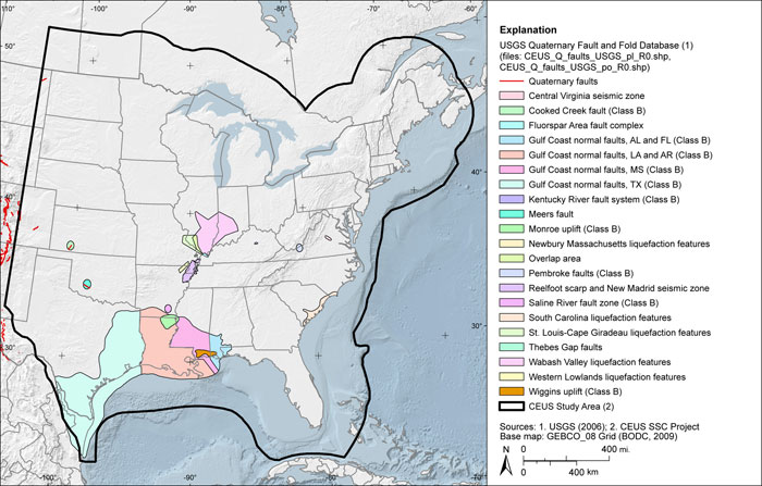
Data Description: The USGS Quaternary fault and fold database presents the locations of faults, associated folds and, in the CEUS, areas of faulting, Quaternary paleoseismic features and seismicity, that are believed to be the sources of magnitude 6 or greater earthquakes in the Quaternary period (less than 1.6 Ma). The USGS uses the database as a source for studies involving probabilistic seismic-hazard analyses. Data are compiled from published literature review and M.S./Ph.D. theses and dissertations. State geologic surveys assisted in the development of the database as well as National Earthquake Hazards Reduction Program (NEHRP) studies. The USGS continually updates this database. See the website for the most current data.
Source (Internet URL, CD/DVD-ROM): Data accessed February 16, 2009, from http://earthquakes.usgs.gov/qfaults/
Author/Publisher/Year: U.S. Geological Survey (and supporting state agency if appropriate)Quaternary Fault and Fold Database for the United States: http://earthquakes.usgs.gov/regional/qfaults/; accessed June 9, 2008.
Data Summary: Obtained from the above website in ESRI shapefile format. Data are presented in geographic coordinates on the North American Datum of 1983.
Disclaimer or Constraints on Use: No constraints have been identified.
Figure A-65
USGS Quaternary fault and fold database (USGS, 2006)