Sheet A-5-CEUS-SSC Project GIS Data Summary
Database of the Geologic Map of North America - Adapted from by J.C. Reed, Jr. et al. (2005)
Download: ![]() Download GIS Data |
Download GIS Data | ![]() Download PDF Figures for Technical Use
Download PDF Figures for Technical Use
Data Files:
| Bathymetry.shp | |
| Cities.shp | |
| Drainage.shp | |
|
|
Faults.shp |
| Geologic_overprints.shp | |
| Glaciation_extent.shp | |
| Rock_in_seafloor_sample.shp |
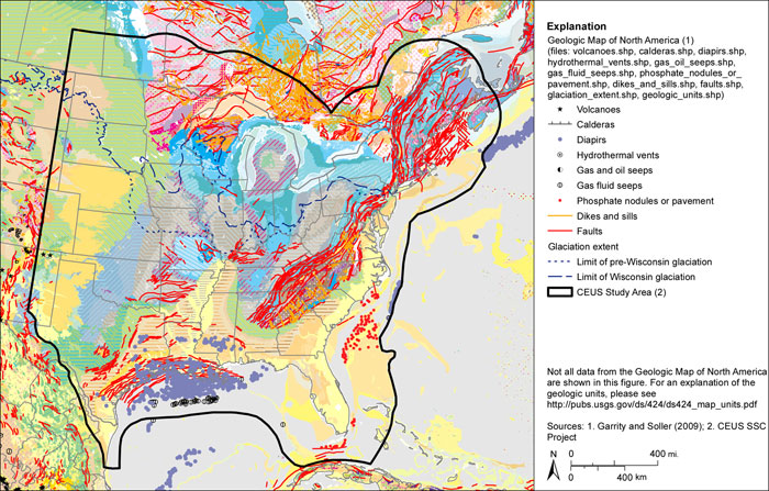
Data Description: Database of the Geologic Map of North America. The data depicts the surface and submarine geology of North America and portions in the Atlantic and Pacific oceans at 1:5,000,000 scale. Digitized from Reed et al. (1993). GIS layers listed above are organized into subfolders (left column) and contain the ESRI shapefiles in the right column. A separate folder named Layer_files contains the ESRI layer symbology developed by the authors for the shapefiles listed above.
Source (Internet URL, CD/DVD-ROM): http://pubs.usgs.gov/ds/424/
Author/Publisher/Year: Garrity, C.P., and Soller, D.R., 2009, Database of the Geologic Map of North America; Adapted from the Map by J.C. Reed, Jr., and Others (2005): U.S. Geological Survey Data Series 424 (CD-ROM); http://pubs.usgs.gov/ds/424/
Data Summary: The USGS source data has been converted to ESRI shapefile format from the ESRI file geodatabase format. ESRI map symbology layers accompany the data with standardized geologic map symbology and color palette. Layers have been converted from a custom transverse Mercator projection to geographic coordinates on the North American Datum of 1983.
Disclaimer or Constraints on Use: Data are not intended to be used at a scale larger than 1:5,000,000.
Figure A-5
Geologic map of North America